

Which Plant Hardiness Zone am I in?
Which Plant Hardiness Zone am I in?
What are plant hardiness zones, and which government agency designates them?


I hope that spring has sprung where you are - or if not, that it will soon!
In the last newsletter, we talked about earthquakes and the U.S. Geological Survey. Today, we’re talking gardens!
If you are planning a garden this year, perhaps you have noticed references to “plant hardiness zones” in materials such as catalogs and seed packets. Typically, these products refer to zoning information provided by the United States Department of Agriculture (USDA). Specifically, a resource known as the “Plant Hardiness Zone Map”.1
Want to learn more about plant hardiness zones and how to figure out which one you’re in? Read on! (Also, make sure to peek at the end of the newsletter for information on current referral specials and discounts for The Civic Librarian.)
What Are Plant Hardiness Zones?
Hardiness zones serve as a general guide for growers to determine which plants (typically perennials) will thrive in their gardens based on the average lowest temperatures in their area.
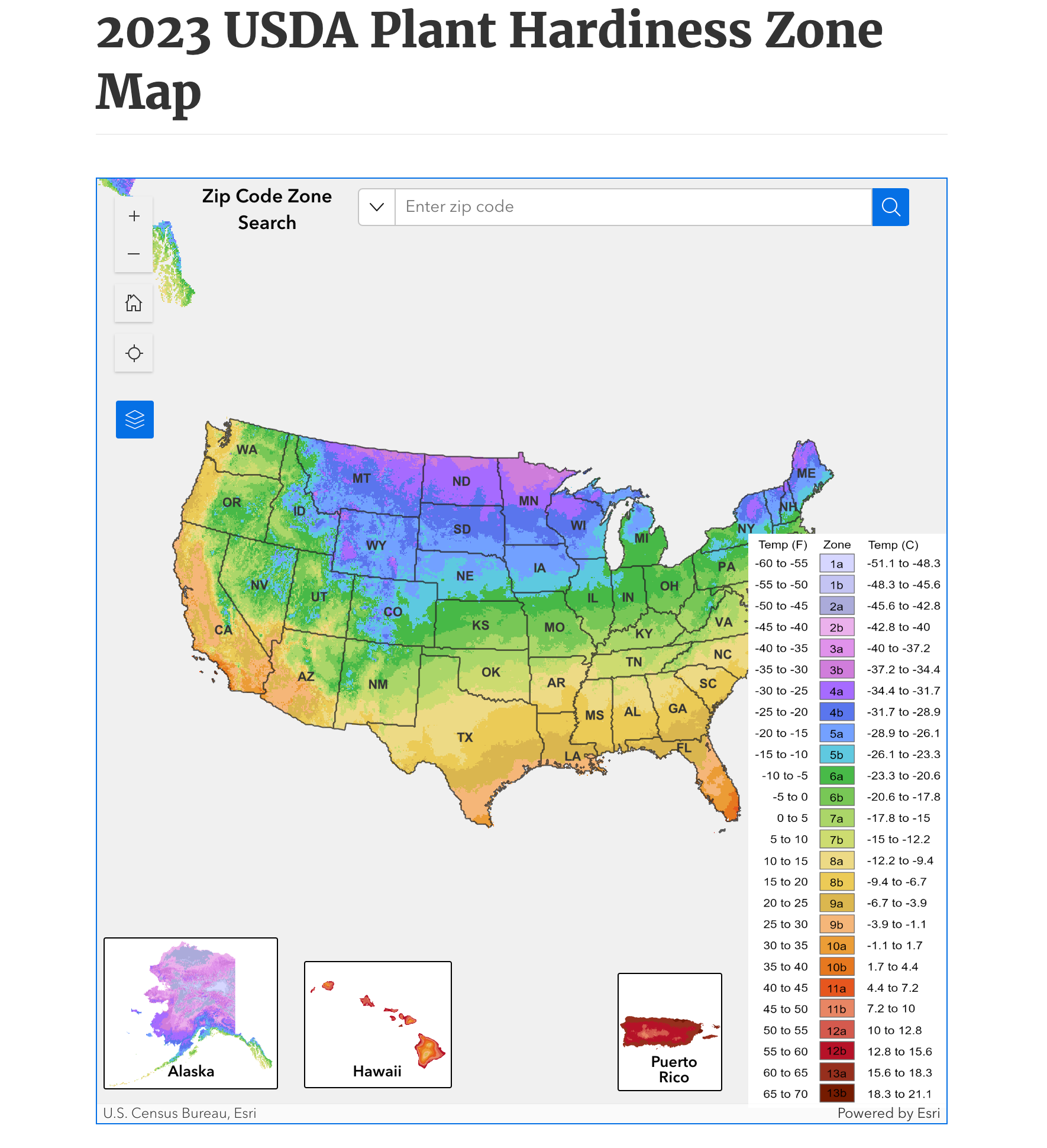
The USDA designates zones based on the “average annual extreme minimum winter temperature” in specific locations. There are 13 zones across the United States and each zone is divided into “A” and “B” half zones.2 The zones are represented visually on the Plant Hardiness Zone Map published by the USDA.
2023 Edition Release of the Plant Hardiness Zone Map
The Agricultural Research Service, an agency within the USDA, released an updated version of the map at the end of 2023. Previously, the map had not been updated since the 2012 edition.
The ARS press release about the new edition gives insight into the data used to designate hardiness zones for the 2023 edition. According to the release, "The 2023 map is based on 30-year averages of the lowest annual winter temperatures at specific locations, is divided into 10-degree Fahrenheit zones and further divided into 5-degree Fahrenheit half-zones.”3
The release also notes that the 2023 map used 1991-2020 data from 13,412 weather stations to designate zones (in comparison to 7,983 for the 2012 edition).4 Some areas, notably Alaska, are represented in greater detail, and about half of the country has shifted into the next warmer half zone. For more information on the implications of the zone shifting, check out Section 4 of the map’s instructional guide.5
Determining Your Zone
To access the map, go to: https://planthardiness.ars.usda.gov/.
Enter your ZIP code in the box at the top of the map to get a closeup of your area. You can compare the color to the map key to get your zone designation.
You can also click directly on your area to get more information about your specific hardiness zone and the others across your state.
Here’s what it looks like when I click on Indiana:
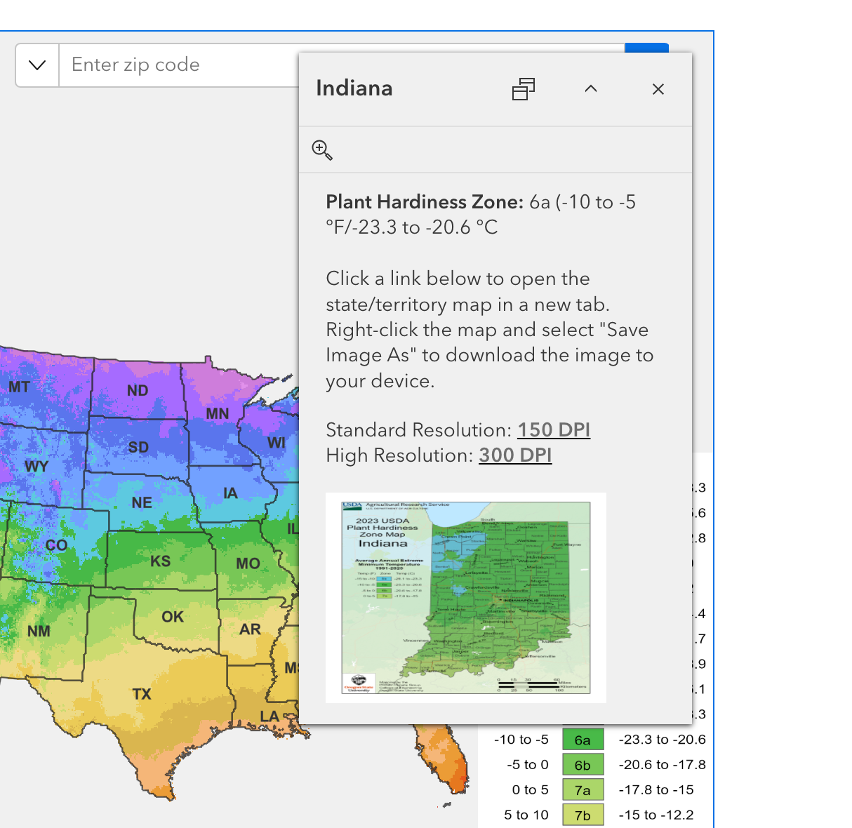
Select one of the resolution options above the image of the state to download a detailed map of its plant hardiness zones and the corresponding temperature information.
(For any public library workers reading, this is a great resource to hand out at your service desks!)

Reference the key to obtain your hardiness zone designation. As you can see, most of Indiana is in 6a, but there are also significant portions in zones 6b, 7a, and 5b.
Now you can buy your perennials with more confidence!
To learn more about how the maps were created and other environmental considerations for planting in your hardiness zone, read through the USDA’s map instructional page.
Happy planting!
A Quick Reminder About the Referral Special
I am still offering my referral special in honor of National Library Week. Thank you to those of you who have shared The Civic Librarian with your peers, and welcome to new readers!
Bring on more of your friends and family by May 19 to try and win a free paid subscription for a year! Read more about the special and other discounts you can get along the way here.
A quick note about the leaderboard - there are a few of you who have done referrals but are not appearing on the leaderboard. I’m not sure why this happened, but I can see all referrals on my end. So don’t worry, yours will be counted on May 19.
Have a great week!
The USDA is considered one of the central and authoritative sources for plant hardiness zoning and data. Respected agricultural authorities such as Farmers’ Almanac use it to advise growers (see this Farmers’ Almanac article on the updated hardiness zones).
The end of the press release also provides additional information as to why so many zones have shifted.
Good info. I'll study up on it!